 Researchers from New York Sea Grant and Cornell University are collecting stories, photos and data about this year’s Lake Ontario shoreline flooding. They’re also looking for anyone with property on or connected to Lake Ontario to take a survey they’ve developed online.
A statement from Sea Grant and Cornell says they’ll use the data to leverage funds for making shoreline communities, businesses and homes more adaptable to high water levels. That could mean raising roads and land levels along the shoreline or guide where to put breakwaters.
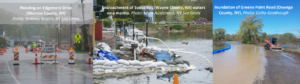
They also want to see if existing flood risk models used by local governments and planning departments have become obsolete. They say if anyone has had property underwater, suffered erosion or damage to shoreline features, disruption of business or travel, they want to know about it.
If you have photos of what happened this spring, they also want to see them. They’re open to surveys and photo submissions through August 31st.