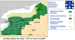
 There are flood watches from the southwestern Southern Tier into the Finger Lakes today as a cold front pushes severe thunderstorms our way. The Rochester area is under flood watch until midnight.
The risk is greatest in late afternoon through this evening, with a chance of showers and thunderstorms producing up to an inch of rain over much of the area, and as much as two inches in some areas. With wet ground and creeks and streams already high, the National Weather Service says it won’t take much to cause stream flooding and urban flooding in low-lying areas.
That much rain will also make conditions worse along the Lake Ontario shoreline, where many hopes and properties were flooded yesterday by waves driven by strong north winds.